 |
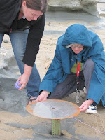
| Mary uses a direction disc |
 |
| Mary adjusts the disc |
 |
| Dean holds a height stick |
 |
| Mary measures |
Museum Victoria and Monash University have conducted “Dinosaur Dreaming” digs since 1995. Originally at the Flat Rocks site outside Inverloch, Victoria, it has evolved to include localities along the Bass and Otway Coasts. Since 2008 this blog has shared images and stories of crew taking part in excavations, fossil bones recovered, and fossilly things we get up to between digs. The most recent dig took place at Twin Reefs for 3 weeks in February 2025.
No comments:
Post a Comment